Pioneer Roads of Arcadia
by Ed Howard
Reprinted from Society News, the newsletter of the Arcadia Area Historical Society
June 2016. Volume 22 Issue 1.
|
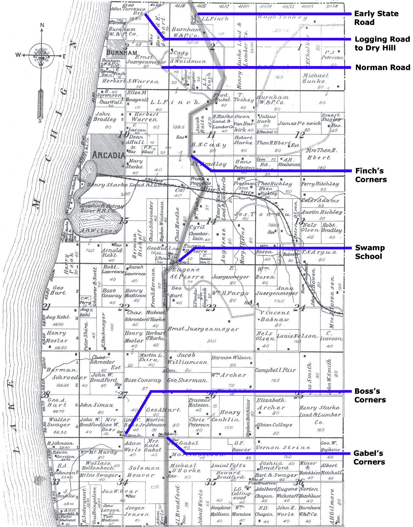
Much due to the concentration on westward expansion, road development in the United States took a heavy east/west orientation throughout the 1800s and even into the early Nineteens. Only the lower two tiers of Michigan’s counties could benefit much from this National financial focus. Even after statehood in 1837, it was decades before Michigan itself offered much state aide to its northern portions. With only limited on-again, off-again state support throughout that time, responsibility for roadways were left to the counties and, ultimately, the townships. Counties like Benzie and Manistee and townships like Arcadia and Blaine were left much on their own to build and maintain any needed roadways. Roads for tourism, of course, were un-thought of during these hard, homesteading times; costly, labor intensive road building was reserved for life-sustaining farm-to-market and log-to-mill type purposes, and it was up to each county or township to build and maintain their own. Of course, most all of the roadways, National or township, had once been narrow Indian pathways, just wide enough to pass through individually. They were gradually trimmed back and expanded by explorers and settlers as they brought their packs and pack animals, teams of oxen, wagons, and eventually their motorized vehicles. So, no wonder it was that a group of Arcadia pioneer ladies at a meeting sometime early last century were remembering the hardships of building and using the primitive roads of their childhood. From notes summarizing that un-dated meeting titled “Pioneer Roads of Arcadia,” we know that Mary Loague Gilbert (daughter-in-law of early settler Sam Gilbert) began the discussion with a reminder that “in the first place, all roads followed the path of least resistance, and ….logging roads followed the hollows for it was easier to cut and skid downhill than to take them up…” She stated that then “nearly all roads went to the beach…for when early settlers of this region were building their homesteads, though made of logs, they required lumber for windows, doors, facing and floors, which was brought up opposite the road (Burnham) with boats…brought to the shore in lighters or rafts and hauled to the home under construction.” Mrs. Gilbert next asked Mrs. Fannie Finch to “present some facts” about early roads as she remembered them. Mrs. Finch began “Now…the road that runs by our home, as I remember it as a child …came down the big hill and in about half way to the beach (To help understand Mrs. Finch’s descriptions please note the northwest portion of the 1903 plat map of Arcadia Township.). Then angled south and east till it came a little west of the present road bed at F. G. (Floyd Gilbert?) corners.” It then ran south to Arcadia or Starkeville, as she said it was then called. The reason for the angled detour was because of “a pond or swale just under the hill north of the east of Burnham Road.” This swale was later filled with logs and sawdust. Then the road was built at the bottom of that hill and “the road which ran through the Burnham Mill yard was discontinued…. first this road was sand, then sawdust and bark hauled in from the Sawmill. Later, clay was hauled in to fill the sandiest spots… at last we have the present good road.” Mrs. John Hovis (Jennie) was then introduced as the final speaker, and her remembrances were thorough and many: “The road now called M 22 was at the time called State Road and was routed on south from Finches Corners [to] up by where the Swamp School house now stands and came on [to] the present site at Gables Corners where a road led west to Boss’s Corners and then south to Pierport.” |
|
|
|
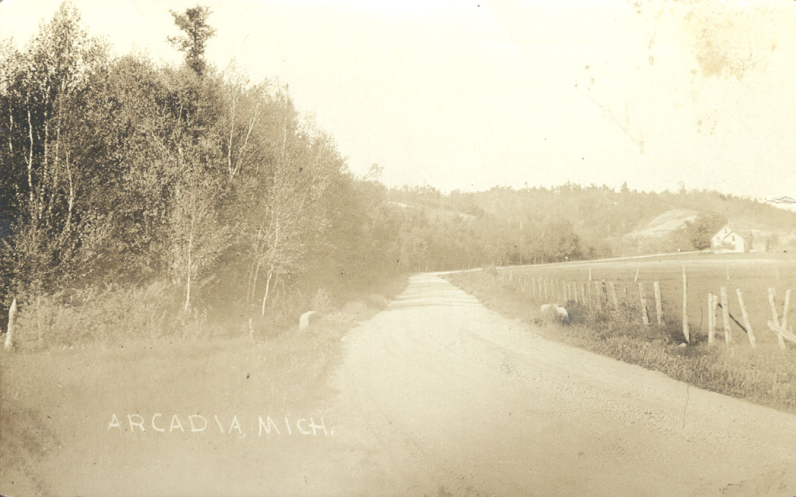
 This is a 1924 photo of the State Road just north of Finch Corners and before Norman Road. |
|
It becomes obvious from Jennie’s use of surnames that wherever two or more roads crossed or connected, those corners were going to bear the names of adjacent property owners. Mrs. Hovis states also that “there was then a road running East and West from the State Road to the Lake on [the] section line (Sorenson Road?). And all that is left of [the] road is some old corduroy over water in what is now the Swamp owned by L.L. Finch…” She next describes the route called Burnham Road which once began as a street in Burnham and ran east all the way to the “State Road” in much the same line as the current Norman Road. She said it was sand where it “wasn’t mud.” Note that Mrs. Finch in her comments had been describing the Norman Road route starting on the east end. Of special interest is Mrs. Hovis’ details of the road that led north out of Burnham (see map) and then turned to a northeast line into Benzie County where it too would cross the “State Road”. Here’s her description: “From Burnham the road running up the hill had a double track used for hauling logs from the region now known as Dry Hill. The two tracks, one for teams going up empty and the other for loaded teams to prevent accidents. At one or other places these roads crossed and where the loaded one started down…the driver let out a yell that could be heard at least part way down…and when he neared where the road crossed there was another yell and so on till he reached the Mill yard with his load.” Little did these loggers know that someday the State Road would be routed a little west and would actually pass over that high bluff above them to the north, and that steep, high ground would be the most scenic of scenic places along a highway called Scenic Highway M22. Jennie’s next description is of now Glovers Lake Road and using it to travel out of Arcadia: “Now the road M 22 from Arcadia to Finches Corners, as I first remember it, a rough corduroy, which means poles or logs laid down in the mud and sawdust or mud hauled on it all…was it ever rough. This at the time was the only road out of Arcadia if you wanted to go south of town by team.” She does mention that both Arcadia and Burnham had piers where boats landed, but she continues “The only trouble with this road was that the spring and fall rains made the mud so deep that more logs and dirt were needed to make it passable.” She then asks the other ladies to just imagine riding over that rough, narrow road with only the swamp and the trees on each side. |
|
|
|
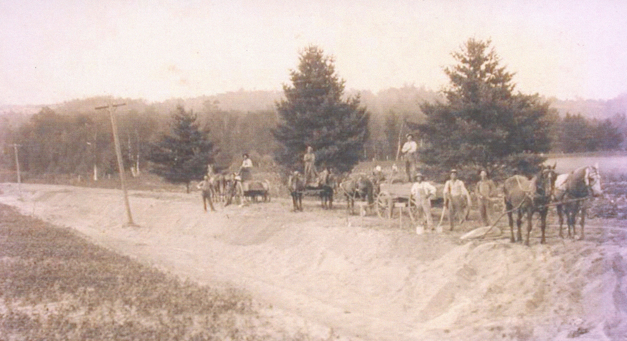
This is a crew of farmers doing their share of local road maintenance sometime in Arcadia’s early history. |
|
It wouldn’t be until the spring of 1916 that a bridge would be built which enabled Arcadians to have a more direct route south out of town. That work would be done by young State civil engineer Walter Howard. Walter, son of John Howard, was a local and had been raised on their farm about three miles north, right on State Road M 22. Before college, Walter had attended the one-time Watervale School and Frankfort High School. His father’s diary reveals that Walter and his crew were actually staying in Arcadia during construction of the bridge (at Matteson Manor?). |
|
|
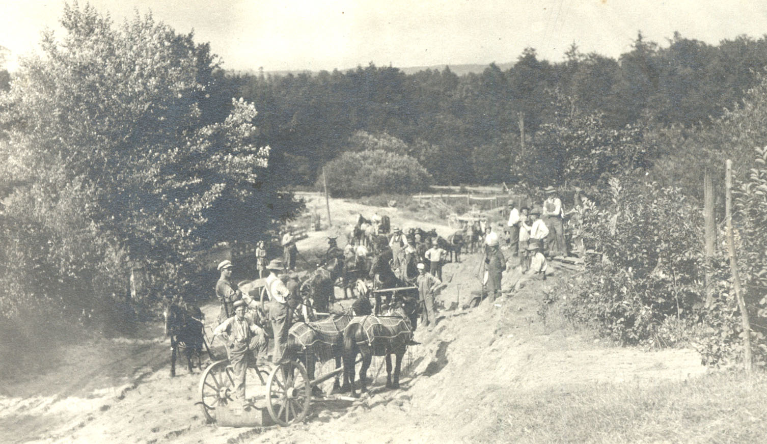
Farmers could work off some of the road tax portion of their property taxes at that time. Using a team and/or equipment counted even more against the tax. Walter Howard, builder of the mentioned Arcadia bridge, was raised here and would have been about twelve years old at the time. First paving of M 22 at this location took place in Sept. 1940. |
This photo is of road work being done on State Road M 22 in front of John Howard’s. |
|
1903 Plat Map of Arcadia Township |
|
|
In final note, to put a couple local roads facts in place, John Howard’s diary also reveals that construction of the new branch of M 22 westward through the now Scenic Turnout began the spring of 1941, and the actual first paving of “ Old M22” north of Arcadia didn’t take place until the fall before, 1940. This writer is young enough to remember them both. |
|